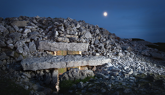

Grange Stone Circle (more correctly termed Circle B as there was apparently four or more circles in the area originally) is one of the most unusual megalithic monuments in Ireland. Almost every aspect of its peculiar set of features has been the subject of much speculation and argument; its construction date and sequence, its original number of stones, the impact of restoration work in the modern era, whether it had an even larger sister site nearby and of particular interest to this piece, its many suggested astronomical interpretations.
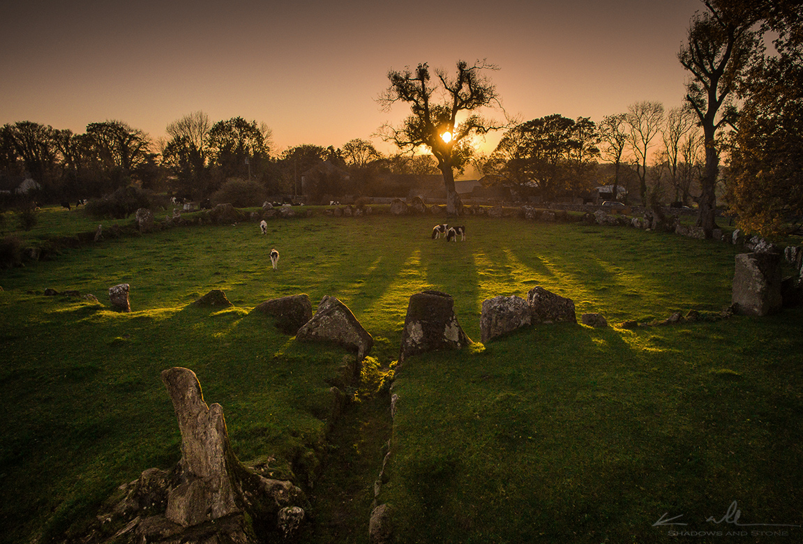
It is a type of monument known as an embanked stone circle, basically meaning that the stones around its circumference are set against a bank of earth and stone. Only a handful of them are known in Ireland but Grange is unique even among these in having a clearly defined, stone-lined passageway entrance. The construction date of the site has been debated in the past, however, more recent excavations by Rose Cleary has established a likely construction date in the Late Neolithic, c3,000-2,600BC.

There is certainly no shortage of astronomical interpretations put forward for the circle. Many people gather here at dawn on the Summer Solstice, when the sun is claimed to appear in the entrance. However, the sunrise first appears well to the left of the entrance and only casts a beam through the giant portal stones long after first light. Archaeologist Aubrey Burl, an expert on stone circles, adds an extra condition, the summer solstice sunrise appears ‘in line’ with the largest stone of the circle in its northern quarter (Burl 2000, 278) Others, like Jack Roberts who is one of the foremost researchers into Irish stone circles for over 40 years, have argued for a Bealtaine/Lughnasa cross-quarter alignment, looking out through the entrance from inside the circle (Roberts 2013, 66)

The first and most long-lived interpretation, however, was proposed by Bertram Windle in 1912. He made the interesting observation that two of the stones opposite the entrance formed what he called a ‘v-notch’, through which an observer, standing at the entrance, could view the setting sun almost as if through the sight of a gun. He suspected that the sunset in question lined up with the cross-quarter day in early November, known as Samhain in the old ‘Celtic Calendar’ (Windle 1912, 287).
Windle engaged the expertise of then Captain, later Vice Admiral Henry Boyle-Somerville, an experienced surveyor and one of the first to study the astronomical potential of Ireland’s stone circles. Bolye-Somerville made the necessary calculations and appeared to have confirmed Windle’s suspicions. There was, however, a caveat. Due to the presence of trees and buildings close by, they could not directly measure the elevation of the horizon from Windle’s proposed viewing point. Instead, they estimated it as being 3 degrees (Windle 1912, 287).
More recently, however, some very thorough and methodical work by Frank Prendergast has shown that the alignment suggested by Windle was in fact incorrect. The horizon estimate used was almost 2 degrees too high, thereby making the date of sunset out by several days (Prendergast 2015).
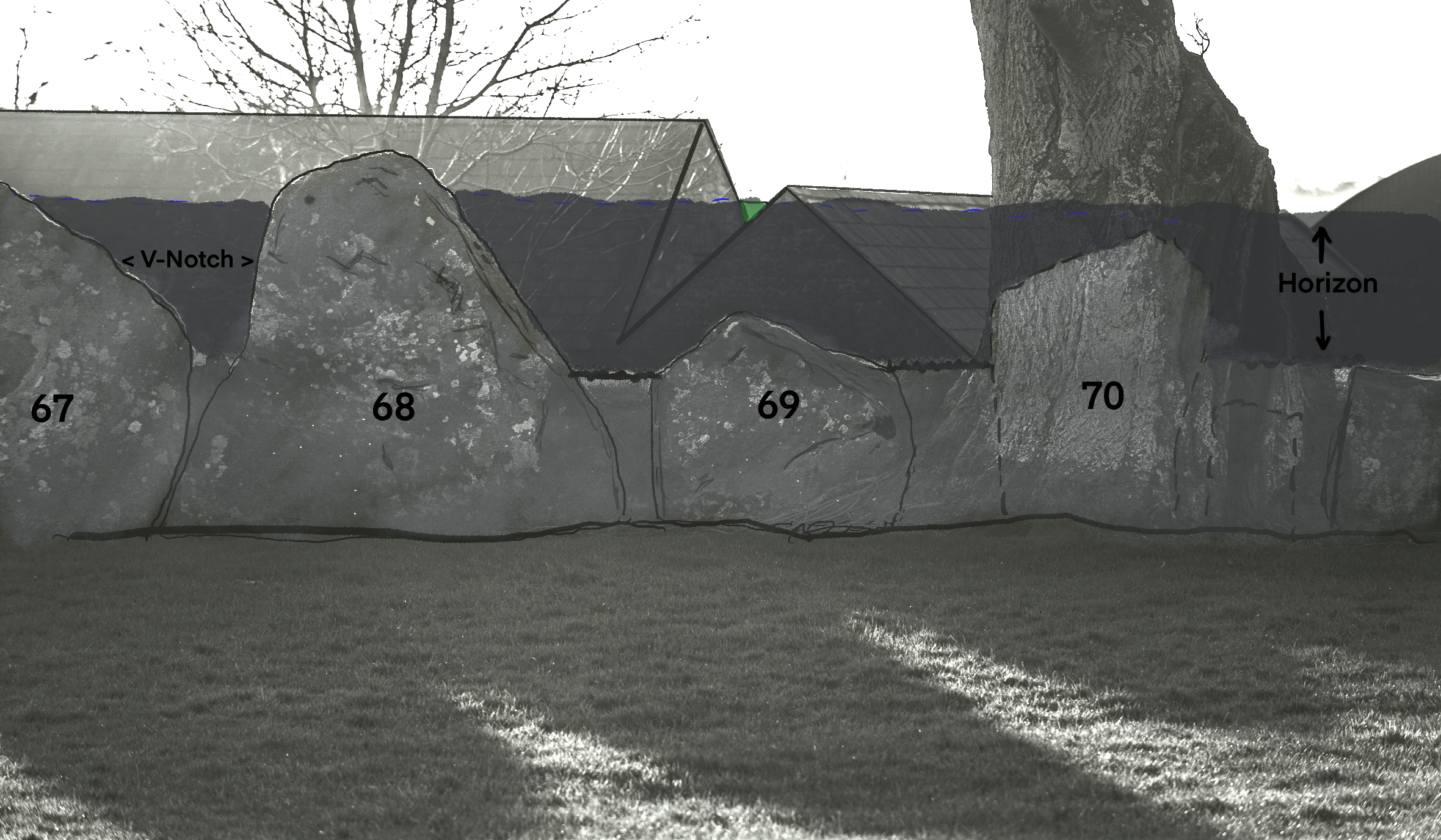
Although this does seem to have settled the proposal made by Windle over a century ago, my own observations over the past decade and a half persuaded me to have a closer look at a more persuasive phenomenon, clearly visible today at sunset on the cross-quarter. The argument made here is that the date proposed by Windle is in fact correct but the previous interpretation of the monument’s axis and sightline has been too preoccupied with his speculations about stones 67 and 68, the so-called ‘v-notch’ stones.
Although Windle described the stones as forming a ‘gun sight’ through which to view the sunset, the elevation proposed in his own calculations contradict this interpretation. My own observations at the site confirm that, to view the sun setting in the gap between the stones, an observer would need to be lying on the ground several metres in front of the two stones. Otherwise, only the ridge on the horizon is visible through the v-notch. It seems to have been possible to observe the sun in the wide gap between the tops of the two stones, but the shape formed by their sloping sides is entirely redundant (fig. 5). Moreover, no other stone circle in Ireland uses a contrived v-notch to mark its axis. Instead, the vast majority use the typically flat top of a single recumbent stone.
There is another potential problem. The sightline proposed by Windle disregards the intentional directionality of the stone-lined passage way. To view the proposed orientation, an observer would walk along the entrance passage and then have to turn their head slightly left to look over to the superfluous v-notch between stones 67 and 68. The v-notch can only be seen in the passageway by standing against its northern side. It is not clear why, if this was the intended sightline, the passageway would be so clearly skewed against it (fig. 6 and 7).
The passageway does have a very clear sightline direction, however. It points directly at Stone 69, the next stone north of the v-notch stones (fig. 1, fig. 6). This is a squat stone whose triangular top barely clears the height of the bank behind it. Its position, however, seems to be emphasised by the larger stones on either side of it, whose tops seem to angle down towards it.

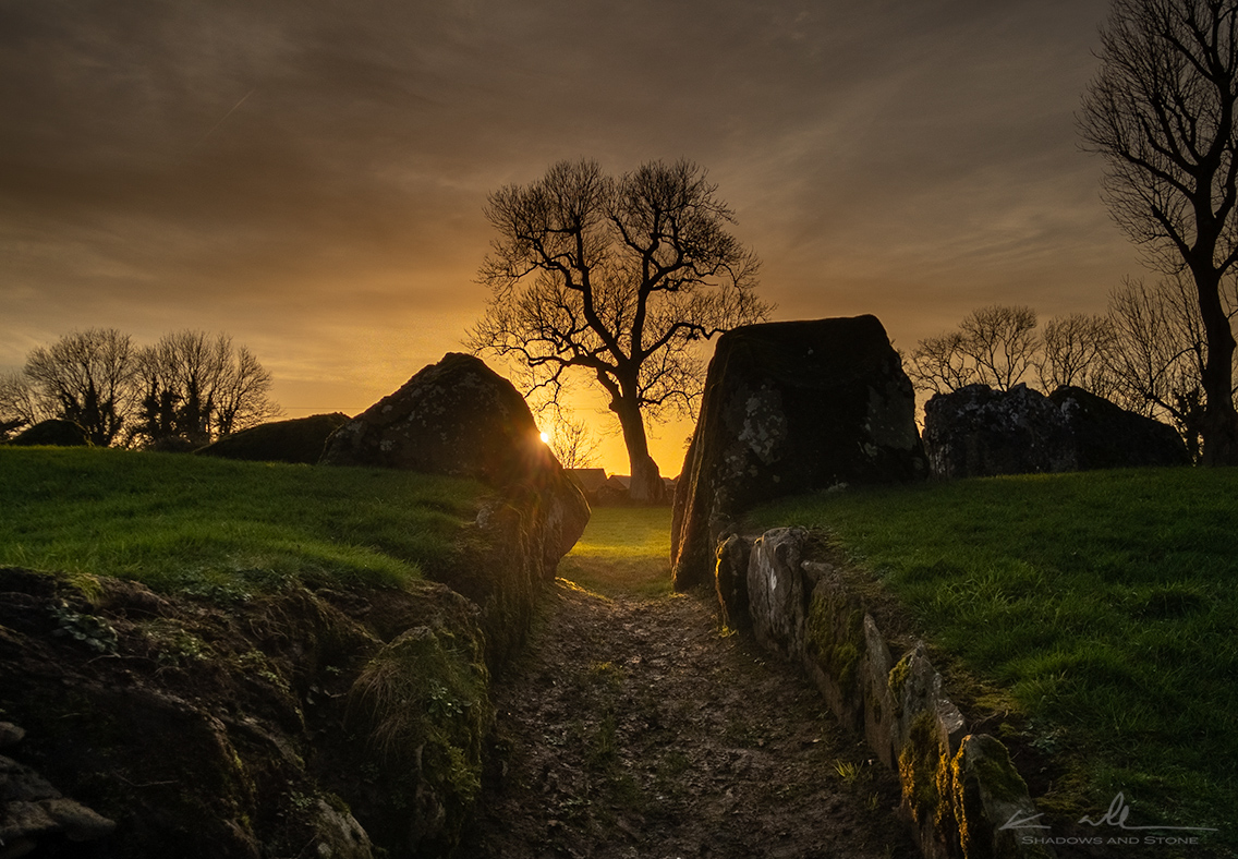
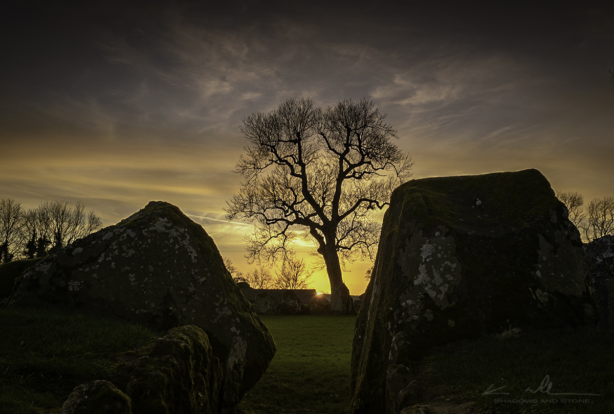
It appears to me, if any alignment was intentional, it is this stone framed through the giant portal stones as seen from the entrance passage. Indeed, in previous years, I had watched the light of the setting sun at the Samhain cross-quarter of November 8th streaming down this passage (fig. 8). The question remained, however, of the actual elevation of the horizon. This is a key factor that determines whether the setting sun could have been an observable target at a specific time and from a particular direction.

Fortunately, the trees and obstacles that blocked direct observation of the horizon at sunset at this particular spot seem to have been cleared in recent years. For the first time in over a century, we can see for ourselves the actual horizon line and the position of the sun. Using a telephoto lens, it’s possible to get a very clear picture of the horizon, exactly where it needs to be seen.
Over the past couple of years, I have returned to the site to make observations of the sunset at the cross-quarter days, both in February and in November. On a clear evening, the setting sun creates a dramatic beam of light along the passage and the shadows cast by the tops of the stones opposite move almost like the hands of a clock, lining up the unmistakably shorter, pointed shadow of stone 69 with the entrance. The photographs I have taken, below, show that the sun does indeed set at the point almost directly above this pointed top (figs. 9 & 10). Due to the change in the angle of the earth’s tilt relative to the sun over thousands of years, this would have lined up with even greater accuracy in the prehistoric past.


Windle’s proposed alignment through the v-notch stones does, however, have one advantage over this new proposed axis towards stone 69. It can be seen in a plan of the site that his alignment crosses through the centre post hole which was found during excavations by Sean O’Riordain in the late 1930s (O Ríordáin 1951, 44). The revised axis proposed here passes north of the post hole and theoretical centre point (fig. 11). It has been argued that this post hole may have been used to mark out the circumference of the circle and therefore forms an important part of its layout. It might be expected that the main axis should pass directly over this point, or close to it.

However, whether this post hole was in fact used to mark out the circle or not, it clearly was not intended to be a precise operation. If there was a central importance to this point, its significance clearly went ‘out the window’ when the stones were actually set in their sockets. There are very significant deviations from a circle which would have been marked out from this post hole. Likewise, the post hole is well out of alignment with the passage (fig. 11).
There also remains the thorny question of previous renovations and other interference with the stone circle and bank. The 1930s excavations showed that many of the stones were loosely placed against the bank and their sockets were in fact above the old ground level. These are likely to be the stones referred to in oral accounts of 19th Century restoration. Rose Cleary, who also excavated the site, argues that it is the smaller stones with sockets above the old ground level that were likely introduced in the 19th Century (Cleary 2018, 110). The entrance portal stones, the stones of the v-notch and the stone I propose to be the axial stone, stone 69 (fig. 12) are all large stones with sockets cut into the old ground level, therefore there is no reason to believe they are modern additions or were repositioned at some point in the past.

O Ríordáin likewise argued that the passage was also an original feature. Local accounts told of the restoration of four stones on the northern wall of the passage. The trench cut through the bank and passage by O Ríordáin demonstrated that these particular stones were modern. However, he argued the layout and direction of the passage itself was original (O Ríordáin 1951, 48).
Some questions, however, can’t be answered here. We can’t tell for sure that this alignment, although spectacular, was intentional. There are several stone circles in the south of Ireland where the axis seems to point in the direction of sunset on the cross-quarter days and I have photographed this event at several of them. Two located close to each other at Carrigagulla both seem to point in this same direction, which does suggest it was intentional.
We also can’t be sure if it the direction of the alignment was through the passage and across the circle, like I have suggested here, or in the opposite direction. On balance, however, I think it is more likely to be towards sunset rather than sunrise. Although Grange Stone Circle is likely to be earlier than the standard Bronze Age stone circles of Ireland, I don’t know of any where a better case can be made for an alignment viewed from the axial stone through the entrance. The alignments that are suspected are towards sunset, mirroring the trend of the Bronze Age wedge tomb monuments to face sunset in the south-west quadrant.
Additionally, although a small group of observers could perhaps witness the sunrise through the passage, the exceptionally large space inside the circle suggests a larger audience was intended. For the remaining observers, the view along the passage towards sunrise would be blocked by the giant portal stones of the entrance. At sunset, however, everyone present could see the sun setting on the ridge in the south west and the shadows of the stones on the south-western corner, moving like the hands of a clock to line up with the entrance. How impressive it would have been for participants to walk around the encircling bank, turn in towards the passage and witness the sun setting opposite as they made their way into the circle for ritual celebrations of the turning of the seasons.
In conclusion, it seems that Windle’s first proposal in 1912 was intuitively correct after all, the circle at Grange does seem to have a cross-quarter Samhain connection. Likewise, Frank Prendergast was correct to show the alignment as proposed by Windle was let down by flaws in the assumptions it was based on. For over a century, the so-called ‘v-notch’ stones have remained something of a red herring, obscuring a more simple and, in my view, spectacular phenomenon whereby the setting sun lights up the specially walled and paved entrance passage while the dark, pointed shadow of the axial stone reaches towards you, before it too fades into the twilight.
References:
Burl, Aubrey (2000) “The Stone Circles of Britain, Ireland and Brittany”. Yale University Press.
Cleary, R (2018). “The Archaeology of Lough Gur”. Wordwell.
Ó Ríordáin, S. P. (1951). “Lough Gur Excavations: The Great Stone Circle (B) in Grange Townland”. Proceedings of the Royal Irish Academy (C) 54: 37–74.
Prendergast, F. (2015). The Great Stone Circle (B) at Grange, Co. Limerick: A Ceremonial Space for All Seasons?. Journal of Skyscape Archaeology, 1(1), 65-92. https://doi.org/10.1558/jsa.v1i1.26955
Roberts, Jack (2013) “The Sun Circles of Ireland”. Bandia Publishing.
Windle, Bertram C. A. (1912) “On Certain Megalithic Remains Immediately Surrounding Lough Gur, County Limerick.” Proceedings of the Royal Irish Academy. Section C: Archaeology, Celtic Studies, History, Linguistics, Literature, vol. 30, pp. 283–306. JSTOR, http://www.jstor.org/stable/25502812. Accessed 7 Nov. 2020.
